|
Note: This page and any Portable Document Format (PDF) or similar files linked from this page are part of an archive and might not contain current information.
On This Page
Geary Corridor Bus Rapid Transit | Van Ness Bus Rapid Transit | Central Subway | Translink | Transit Effectiveness Project
Geary Corridor Bus Rapid Transit
The San Francisco County Transportation Authority (SFCTA), in partnership with the San Francisco Municipal Transportation Agency (SFMTA), the Planning Department, the Department of Public Works and Golden Gate Transit, launched a study of the benefits and impacts of potential designs for Geary Corridor Bus Rapid Transit.
Bus rapid transit (BRT) is a quick and relatively inexpensive way to speed up buses and make service more reliable and comfortable. BRT systems typically:
- Give buses their own traffic lane so they can run faster with fewer impediments;
- Give buses priority at traffic signals so they spend less time stopped at red lights;
- Provide real time information to customers so they know when the next bus is coming;
- Build high-quality and well-lit bus stations to improve safety and comfort; and
- Provide streetscape improvements and amenities to make the street safer and more comfortable for pedestrians and bicyclists accessing the transit stations.
Geary Boulevard is the most heavily used transit corridor in the northern part of San Francisco. Almost 50,000 daily transit customers rely on Geary bus service that can be slow and crowded. The implementation of BRT features, such as dedicated bus lanes and high-quality bus shelters, are being considered to improve service for existing customers, attract new transit customers and prevent increased auto congestion caused by existing customers switching to driving because of dissatisfaction with transit.
The SFCTA and other public agencies are working collaboratively with the Geary Citizens’ Advisory Committee as well as inviting public participation through community meetings. With the approval of the feasibility study, the Study team is now poised to begin more detailed analysis through an environmental review of BRT on Geary. Once the project scope is refined through this study, the engineering and construction phases can begin, with BRT service potentially beginning in 2011/12.
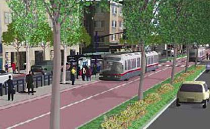
Model of Geary BRT Corridor
Van Ness Bus Rapid Transit
The San Francisco Transportation Authority and the SFMTA have launched the Van Ness Avenue Bus Rapid Transit Project to bring major bus improvements to the Van Ness corridor, possibly including dedicated bus lanes, distinctive boarding stations, real-time bus arrival information and urban design treatments.
Using an approach similar to the Geary study, various BRT design options have been developed collaboratively and are being refined in an Environmental Impact Report/Statement (EIR/S).
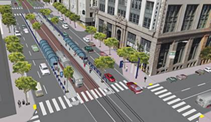
Model of Van Ness BRT Corridor
Central Subway
The Central Subway, Phase 2 of the Third Street Light Rail extension, will add 1.7 miles of light rail track north from the terminus of the IOS at Fourth and King Streets. It would proceed north along Fourth Street, serving a surface station between Brannan and Bryant Streets, to a double portal structure between Harrison and Bryant Streets where the alignment transitions from surface to subway. The subway tunnel would proceed north under Fourth Street to serve three subway stations: a station in the vicinity of the Moscone Convention Center complex, a combined Union Square/Market Street station on Stockton Street between Market and Geary, and a Chinatown station on Stockton at Jackson.
Muni, in partnership with the community, will structure this project to:
- Significantly reduce travel times and increase service reliability;
- Reduce gridlock and improve travel time for motorists;
- Provide direct connections to CalTrain, BART and other transit systems in the region;
- Help generate economic opportunities and jobs for local residents and business owners;
- Improve access to Chinatown.
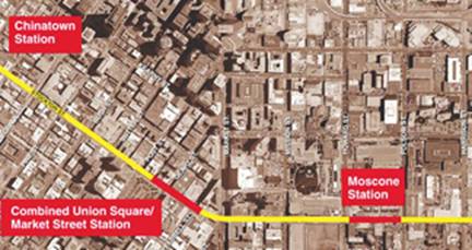
Planned subway route from Moscone Center to Chinatown
Translink
The Translink® smart card fare payment system was launched by the Metropolitan Transportation Commission (MTC) as a pilot project in 2002 and is now approaching full implementation by a number of Bay Area transit agencies. Translink can now be used on AC Transit, on Golden Gate Transit and ferries and on the Dumbarton Express. It is expected to be fully implemented on BART, Caltrain and Muni by 2010. Cards can be obtained by calling the Translink Customer Service Center at 877.878.8883 (TTY 800.735.2929), or by downloading an application from www.translink.org.
The Translink card is a stored value card that can be used to pay full and discounted fares (using an RTC Translink card) for travel on participating transit systems. The value of the fare is deducted from a Translink customer’s account when the card is tagged by a card reader. Translink card value can be replenished in a variety of ways including using an add fare machine in shared Muni/BART stations.
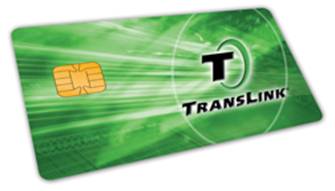
Translink Smart Card
Transit Effectiveness Project
The Transit Effectiveness Project (TEP) is the first comprehensive effort to review and evaluate the Muni system in over 25 years. To study the needs of Muni’s diverse ridership, the TEP partnered with the SFMTA’s Accessible Services department, the Mayor’s Office on Disability, and members of the general public to review how well the Muni system is serving seniors and people with disabilities. The TEP surveyed senior and disabled customers on how they access the system, the current barriers to riding Muni, and how service can be improved.
The TEP’s Staff Recommendations focus on service factors aimed at increasing customer convenience: improved reliability, reduced travel time, more frequent service and updated Muni bus routes and rail lines that track with current travel patterns. The recommendations focus on providing resources where they are most needed. This includes new routes and route extensions, more service on busy routes and elimination or consolidation of certain routes or route segments with low ridership. By investing in delay reduction techniques and shifting resources to crowded routes, these recommendations will deliver more service to Muni customers without increasing Muni’s operating budget; accordingly, the system will be more efficient, effective, and customer friendly.
As the TEP develops its recommendations, the team continues to work with senior and disabled advocates to address their transit needs. For more information, visit the TEP website at www.sfmta.com/tep or call 415.701.4599, TTY 415.701.2323.
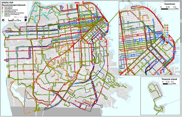
SFMTA TEP Recommendations
Continue to Chapter 9: Muni Accessiblity Advisory Committee
Return to Table of Contents
|


